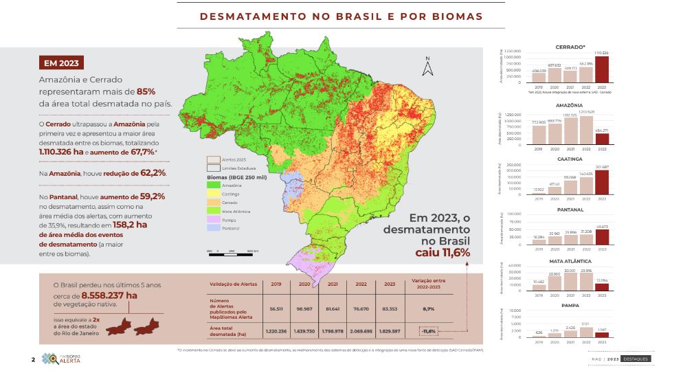
The Cerrado surpassed the Amazon for the first time and presented the largest deforested area among the biomes, totaling 1,110,326 ha and an increase of 67.7%
In Amazon, the area deforested in 2023 was 454,300 hectares - a drop of 62.2% compared to 2022. There was a reduction in all states except Amapá, where there was a 27% increase in deforestation. In the Amacro region, which brings together the states of Amazonas, Acre and Rondônia - and which was once considered Brazil's new deforestation front - there was a 74% drop in the deforested area, which stood at 102,956 hectares in 2023. The data comes from the Annual Report on Deforestation (RAD) 2023, launched on May 28th.
> > Access the main highlights of RAD 2023
Of the 559 municipalities in the Amazon biome, 436 had some deforestation detected in 2023, or 78% of the total. All of the 10 municipalities with the most deforestation in the Amazon saw a drop. Of the 50 municipalities that lost the most native vegetation in 2023, 13 are on the list of priority municipalities in the Amazon biome (Ordinance GM/MMA 834 of 2023) and all of them showed a drop in deforested area compared to 2022.
“There has been a reduction in the average size of alerts and in the area deforested in most states, including the critical Amacro region. On the other hand, there is a possible displacement of this deforestation, which is growing in other biomes, particularly in the Cerrado, which had the largest deforested area in Brazil in 2023,” points out Larissa Amorim, from MapBiomas' Amazon team.
Cerrado: Matopiba overtakes the Amazon and takes the lead in deforestation in Brazil
Cerrado also leads deforestation in protected territories
Pampa: reducing forest loss
The Pampa recorded a 50% drop in deforested area in 2023, which totaled 1,547 hectares. Of the 231 municipalities in the biome, 97 had some deforestation detected in 2023, or 42% of the total. Only five of them accounted for more than half (51%) of the total deforestation in the biome: Encruzilhada do Sul (334 hectares), Piratini (208 hectares), Herval (130 hectares), Canguçu (77 hectares) and Bagé (49 hectares).
More than three quarters (77.7%) of the deforested area is forest and just under a third (21.9%) is grassland. However, the current systems for detecting deforestation in the Pampa (such as GLAD and SAD Pampa) are calibrated for the suppression of forests and, as a result, do not yet monitor the suppression of grassland vegetation efficiently. This is precisely the typical and predominant native vegetation in this biome.
“If we consider the mapping data from MapBiomas Collection 8, in the last five years the annual average of the area removed from grassland vegetation has been 146,000 hectares. Therefore, the drop observed in forest removal in 2023, although positive, does not reflect the reality of all types of native vegetation in the biome. This reinforces the need to improve deforestation detection systems, especially for grassland vegetation, especially at a time when the relationship between the loss of native vegetation and the intensity of flooding is becoming clearer,” says Eduardo Vélez from MapBiomas' Pampa team.
Pantanal: Corumbá, MS, accounts for half of deforestation no bioma
At 2023 Pantanal recorded the largest average area of deforestation events among the biomes (158.2 hectares) and a 59.2% increase in deforestation compared to 2022. In all, 49,673 hectares of native vegetation were cleared last year. For the third year running, the Pantanal had the highest average rate of deforestation: 2.1 hectares/day per deforestation event. Forest and savannah formations account for 73% of deforestation in the biome. Almost all (99 %) of the deforestation in the biome is in private areas registered with the CAR.
The municipality of Corumbá (MS) accounts for 60% of the Pantanal's territory and half of the deforestation recorded in the biome last year. It is also the fifth most deforested municipality in Brazil in 2023. More than half (52%) of deforestation in Mato Grosso is in the Pantanal (a biome that represents less than a third of the state's territory).
In addition to extreme drought events in the biome, deforestation has been another major threat to the Pantanal. “Deforestation of forests and savannahs to form exotic pastures is happening on a large scale. The preservation of these forested areas and the management of pastures are fundamental for maintaining the biodiversity of fauna and flora, together with the Pantanal's traditional livestock systems,” explains Eduardo Rosa, coordinator of MapBiomas' Pantanal team.
Caatinga: deforestation has increased throughout the biome
More than a fifth (22%) of the alerts validated throughout Brazil in 2023 were in the Caatinga, which accounted for 11% of the area deforested in Brazil last year. This amounted to 201,687 hectares - an increase of 43.3% compared to 2022.
At least one deforestation event was recorded in 1,047 (87%) of the 1,209 municipalities that make up the Caatinga biome in 2023. More than 4,302 hectares were deforested by renewable energy projects (wind and solar).
Within the biome, Bahia leads the way in deforestation, with 93,437 hectares - an increase of 34% compared to 2022. Next comes Ceará, with 32,486 hectares, representing an increase of 28%. The largest percentage increase was recorded in Rio Grande do Norte: 62% (a total of 9,133 hectares). In Only one state saw a reduction in deforestation: Pernambuco, with 15,996 hectares - a 35% drop compared to 2022.
“The greatest deforestation seen in the Caatinga has been driven by the expansion of agricultural activities, especially in the agricultural frontier of MATOPIBA. One example is the municipality of Barra, in Bahia, where the greatest deforestation and alert in the biome has been recorded. One phenomenon we have captured is deforestation for the purpose of setting up solar and wind farms, which is growing across the biome,” explains Washington Rocha, coordinator of MapBiomas' Caatinga team.
Atlantic Forest: deforestation down 59%
In 2023, 12,094 hectares of Atlantic Forest were deforested - a 9% drop on the previous year. The reduction occurred in all of the biome's states, both in terms of deforested area and number of alerts. In the biome, Minas Gerais reduced its deforested area by 60% (more than 7,000 hectares); in Bahia, the drop was 53%; in Paraná, it was 71%. Despite this, of the 10 municipalities with the most deforestation, the first two are in Bahia and the remaining eight in Minas Gerais.
The average area deforested per day and the average number of deforestation events both fell by more than 50% compared to 2022. The biggest reductions in proportion were observed in alerts larger than 100 hectares: 88% less deforested area compared to 2022 and 90% fewer deforestation events.
“Agriculture is still the main driver of deforestation in the Atlantic Forest, in addition to the expansion of cities, in 2023 we will see areas deforested by natural disasters caused by rainfall in São Paulo and by mining in Minas Gerais,” points out Natalia Crusco, technical coordinator of MapBiomas' Atlantic Forest team. “The data on deforestation in the Atlantic Forest is compatible with the increase in actions to combat illegal activities in the biome, which has the lowest proportion of remaining forests in the country. The trajectory shows that the commitment to zero deforestation can be achieved in the Atlantic Forest,” adds Luis Fernando, coordinator of the MapBiomas Atlantic Forest team.